If you’ve ever tried to look up a property boundary in Wisconsin and ended up more confused than when you started, you’re not alone. Parcel maps can look like a jumble of lines, numbers, and codes but once you understand what you’re actually looking at, they become one of the most useful tools for property research, land use planning, and zoning questions.
This guide walks you through how to read a Wisconsin parcel map, what each element means, and where to find the right map for each county.
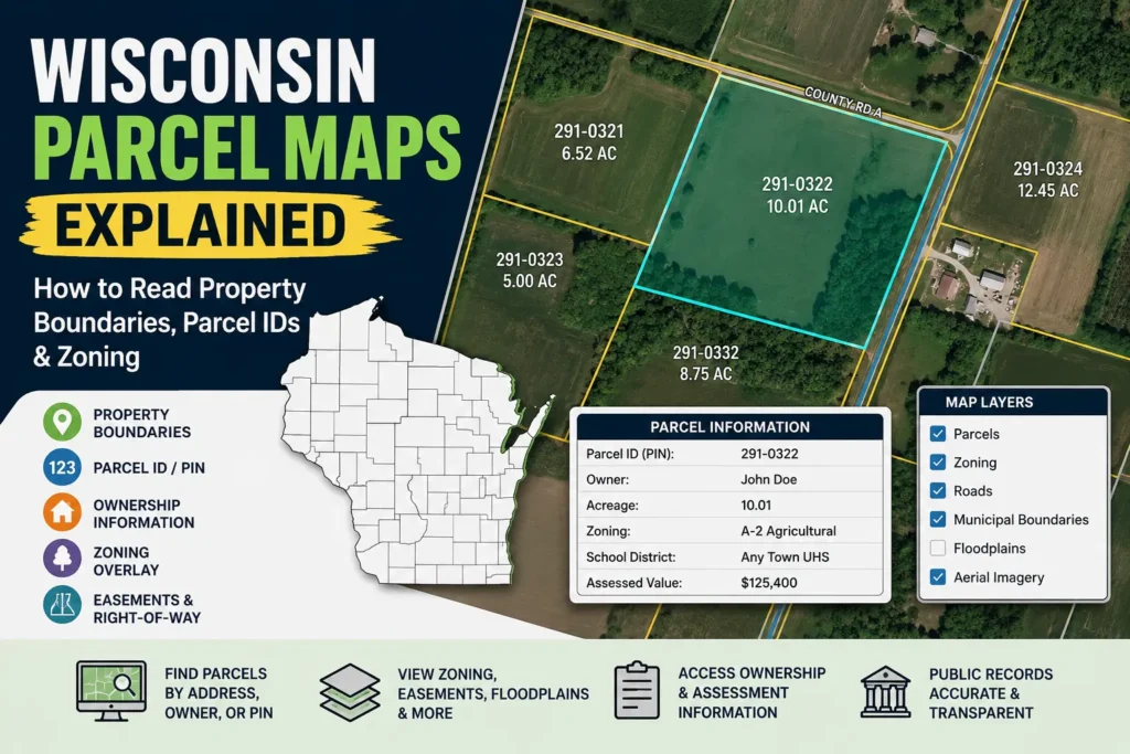
Table of Contents
What Is a Parcel Map?
A parcel map is an official record that shows individual land parcels basically, each separately owned piece of property within a given area. In Wisconsin, these maps are maintained at the county level, which means every county has its own system, its own online viewer, and sometimes its own way of labeling things.
Each parcel on the map is tied to a unique parcel identification number (PIN), also called a parcel ID. That number connects the map to ownership records, tax information, zoning classifications, and any legal descriptions on file with the county.
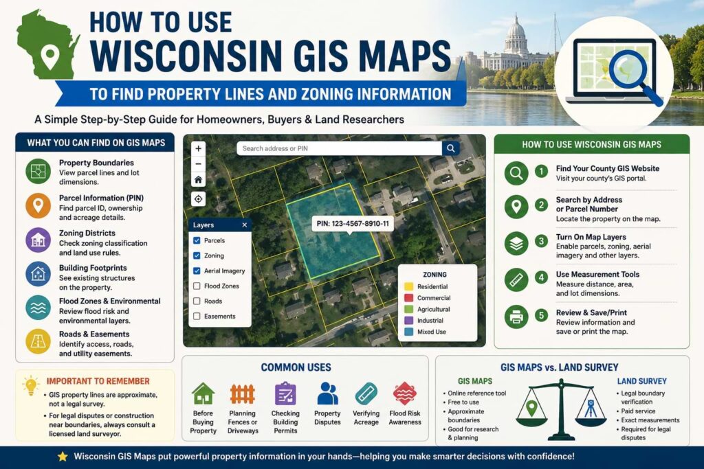
Key Elements on a Wisconsin Parcel Map
Before jumping into specific counties, it helps to know what you’re looking at on any parcel map in the state.
Parcel Boundaries These are the lines that outline each property. They may follow roads, rivers, lot lines, or survey markers. The shape and size of a parcel can tell you a lot a long narrow parcel along a road often indicates an older subdivision pattern, while irregularly shaped parcels usually reflect natural features or historical land splits.
Parcel ID / PIN Every parcel in Wisconsin has a unique identifier assigned by the county. The format varies some counties use a simple numeric code, others include township, range, and section data embedded in the number. When you’re researching a specific property, this is the number you’ll use to pull up tax records, deed history, or zoning details.
Acreage Most parcel maps show the total acreage of each parcel, either directly on the map or in a pop-up when you click on a parcel in an online viewer. This is the assessed area used for tax purposes and may differ slightly from a survey measurement.
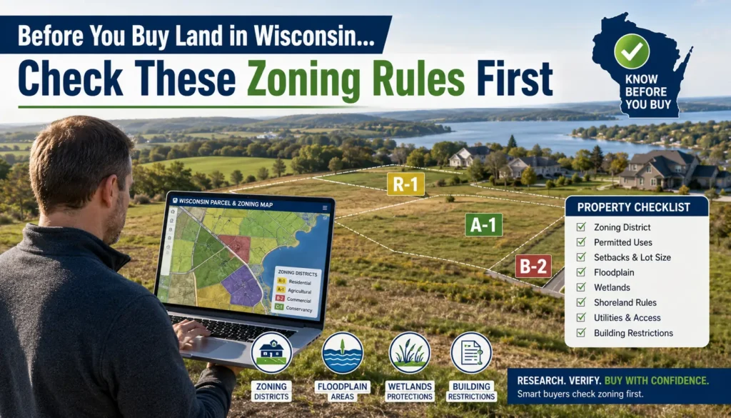
Zoning Overlay Many county parcel viewers allow you to toggle zoning layers on top of the parcel map. Zoning codes tell you how a parcel is classified residential, agricultural, commercial, industrial, or mixed-use. In rural Wisconsin counties, agricultural zoning (A-1, A-2, etc.) is common, while urban areas show a wider range of residential and commercial classifications.
Ownership Information Clicking a parcel on most county viewers pulls up the owner’s name, mailing address, and assessed value. This information is public record in Wisconsin under state open records law.
Right-of-Way and Easements Roads, utilities, and drainage easements often appear as separate layers. A parcel may have recorded easements that don’t show up on the base map unless you toggle those layers or pull the full deed.
County by County Guide
Wisconsin has 72 counties, each managing its own land records. Here’s how to navigate parcel maps in the most commonly searched counties.
Dane County
Dane County home to Madison has one of the more robust online mapping systems in the state. The Dane County Land Information Office runs an interactive viewer where you can search by address, parcel number, or owner name. Parcels are color-coded by zoning district, and the system lets you toggle layers for floodplains, wetlands, and tax districts.
One thing to watch in Dane County: the city of Madison and surrounding municipalities each have their own zoning codes, so a parcel inside Madison’s city limits falls under Madison’s zoning ordinance, not the county’s. Always check which jurisdiction governs the parcel you’re researching.
Milwaukee County
Milwaukee County parcels are searchable through the county’s online property search portal. Given the density of urban parcels, the map viewer here is more detail-focused parcel sizes are smaller, and zoning classifications are more granular than in rural counties.
Milwaukee County also integrates assessment data directly into the viewer, so you can see current assessed value, last sale price, and any tax delinquency status alongside the parcel boundaries.
Waukesha County
Waukesha County operates its own GIS viewer through the Register of Deeds and Land Information office. The county’s parcel data is updated regularly and includes links to recorded documents for each parcel. If you’re researching a property for a land purchase or zoning variance, Waukesha’s system makes it relatively straightforward to pull deed history and recorded plats alongside the parcel map.
Brown County
Brown County (Green Bay area) provides parcel information through its Land Information Department. The viewer allows searches by address or parcel number and displays basic ownership and assessment data. Brown County’s rural parcels, particularly in the northern townships, tend to have more complex boundary descriptions tied to original government survey lines.
Rock County
Rock County uses an online GIS portal that integrates parcel data with aerial imagery. The county covers a mix of urban areas like Janesville and Beloit alongside significant agricultural land, so parcel sizes and zoning classifications vary considerably. The viewer lets you overlay road layers, municipal boundaries, and watershed data useful for anyone doing environmental or land use research.
La Crosse County
La Crosse County’s parcel viewer is accessible through the county’s Land Records office and includes integration with the state’s official Wisconsin Land Information Program (WLIP) data. Parcels along the Mississippi River in La Crosse County often have additional floodplain and shoreland zoning overlays that are worth checking before any land use decision.
Outagamie County
Outagamie County (Appleton area) maintains an interactive parcel map with ownership, assessment, and zoning data. The county has been expanding its GIS capabilities in recent years, and the viewer now includes links to scanned plat maps and recorded subdivision documents.
Eau Claire County
In Eau Claire County, the online parcel viewer connects to the county’s land records and tax systems. Rural parcels in the western townships often span larger acreages, and the viewer is useful for checking township road access and easement information alongside ownership details.
Sauk County
Sauk County which includes the Wisconsin Dells area and significant tourism land has parcel data available through its county GIS office. Given the mix of resort, agricultural, and residential land, zoning overlays are particularly relevant here. Many parcels in the Dells area carry specific shoreland and tourism zoning classifications that affect what can be built or operated on the land.
Marathon County
Marathon County (Wausau area) offers parcel lookups through its online land records system. The county has a strong agricultural and forestry presence in its northern and western townships, and parcel boundaries in those areas often trace back to original public land survey corners.
How to Use Wisconsin’s Statewide Resources
Beyond individual county systems, Wisconsin has a few statewide tools worth knowing.
Wisconsin Land Information Program (WLIP) The WLIP coordinates land information standards across all 72 counties and provides funding for county land records modernization. Their portal aggregates parcel data from participating counties and can be a useful starting point if you’re researching properties across multiple counties.
Wisconsin DOT Highway Maps and Right-of-Way Data If a parcel borders a state highway, DOT right-of-way data can clarify where the road corridor ends and the private parcel begins a common source of confusion in rural areas.
Wisconsin DNR Mapping For parcels near lakes, rivers, or wetlands, the DNR’s mapping tools layer in environmental and regulatory data that county parcel viewers don’t always show including shoreland zoning, floodway boundaries, and navigable waterway classifications.
Common Things People Get Wrong
Assuming county and municipal zoning are the same.
In Wisconsin, cities and villages generally administer their own zoning ordinances separate from the county. If a parcel is within an incorporated municipality, the city or village’s zoning rules apply, not the county’s.
Confusing parcel boundaries with survey lines.
A parcel map shows the legal record of ownership boundaries, but it’s not a survey. Discrepancies between the map and actual physical conditions on the ground require a licensed land surveyor to resolve.
Overlooking easements
The parcel boundary shown on the map represents ownership, but portions of that parcel may be subject to recorded easements for utilities, drainage, or road access that limit what the owner can do with that land. These are typically found in the deed and easement records, not the parcel map itself.
Final Thoughts
Reading a Wisconsin parcel map isn’t complicated once you understand the structure. The key is knowing which county system you’re working in, what layers to turn on, and when to cross-reference with other data sources like deeds, plats, and zoning ordinances. Each county has its own quirks Milwaukee handles things differently than Sauk County or Marathon County but the core logic is the same across the state.
If you’re doing anything beyond basic property research buying land, applying for a zoning variance, checking development rights it’s worth verifying the details with the county’s land information or zoning office directly. Maps are updated regularly, but recorded documents are always the definitive source.
Editorial Note: This guide is for informational purposes only and is based on publicly available Wisconsin county land records resources. Parcel maps may not reflect recent surveys, boundary adjustments, or recorded easements. For legal boundary determinations, consult the county land records office or a licensed Wisconsin land surveyor.