A family in Sauk County made an offer on a lakefront lot, imagining a cabin and a dock. Closing day came and went. Then they found out: shoreland setback rules under Wisconsin Administrative Code NR 115 prohibited any structure within 75 feet of the ordinary high-water mark. Their buildable footprint was a strip of land barely big enough for a shed.
They could have known this before writing the check. Wisconsin zoning law is almost entirely local. There is no single state portal that tells you what you can do on a specific parcel. The rules in Dane County differ from Waukesha County. A town’s ordinance can layer on top of county rules. Shoreland, floodplain, and wetland overlays can restrict a parcel even when its base zoning looks clean. This guide walks through exactly how to pull all of it before you commit.
Quick Answer: To check zoning laws before buying property in Wisconsin, find the parcel ID, review the county zoning map, check shoreland, floodplain and wetland overlays, verify permitted uses in the zoning ordinance, and contact the county zoning office for confirmation before making an offer.
Why Wisconsin Zoning Is Harder to Research Than Other States
Zoning in Wisconsin varies by type, class, and authoritative jurisdiction. Zoning type and zoning class definitions may also vary between jurisdictions, making them potentially incompatible with one another which is why zoning can be difficult to seamlessly aggregate at the regional and statewide scale and it is generally best to contact the authoritative jurisdiction directly for the most complete zoning data.
That means one parcel can carry multiple overlapping layers of regulation at the same time:
| Layer | Who Controls It | What It Restricts |
|---|---|---|
| General/Comprehensive Zoning | County or Municipality | Land use type, structure type, density |
| Shoreland Overlay (NR 115) | County (state minimum standards) | Setbacks, impervious surface, vegetation |
| Floodplain Overlay (NR 116) | County + FEMA | Building elevation, flood insurance, fill |
| Wetland Regulations | Wisconsin DNR + Army Corps | Filling, grading, construction near wetlands |
| Farmland Preservation Zoning | County + DATCP | Agricultural conversion restrictions |
| Town Ordinance | Individual town | May add restrictions on top of county rules |
Every one of these can apply to the same piece of land simultaneously. You need to check all of them.
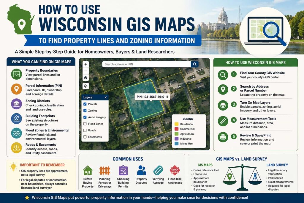
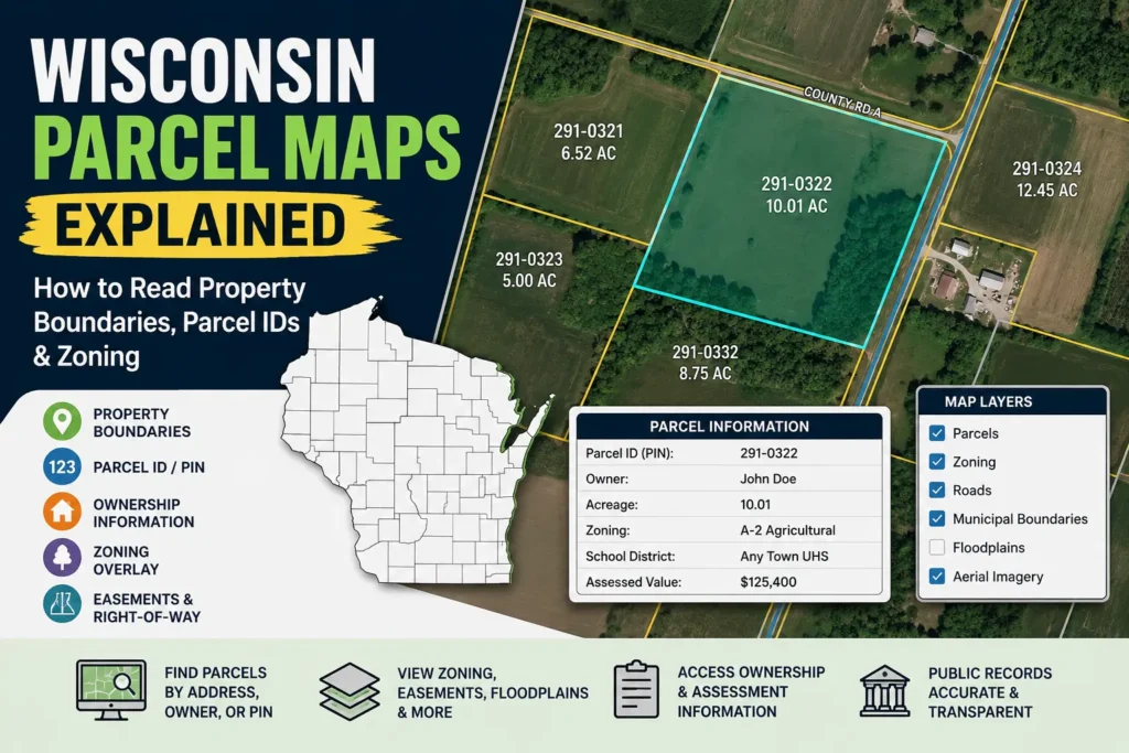
Step 1: Find the Parcel ID and Zoning Designation
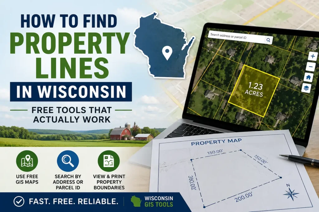
Start with the parcel ID typically found on the tax bill or in your county’s online property tax database. Every county in Wisconsin has a GIS mapping portal. Search “[county name] Wisconsin zoning map” or “[county name] parcel viewer.”
Enter the parcel ID or street address. The map will return the base zoning classification. Common designations you’ll see:
R-1 / R-2 / R-3 — Residential (single-family, two-family, multi-family respectively)
B-1 / B-2 / C-1 — Business or Commercial
A-1 / A-2 — Agricultural (A-2 often allows one residence; A-1 usually does not)
M-1 / I-1 — Industrial or Manufacturing
RR — Rural Residential (common in exurban Wisconsin)
C or Conservancy — Environmentally sensitive land, very restricted development
Real example: A buyer searching a parcel in Polk County pulls up the county GIS and sees the zoning listed as A-2. That designation typically allows one single-family home on a minimum lot size but restricts subdivision and commercial use. A neighboring parcel zoned Conservancy is listed for $40,000 cheap for a reason. It cannot be built on at all.
After identifying the base zone, look up that specific zone in the county’s zoning ordinance — search “[county name] Wisconsin zoning ordinance PDF.” The ordinance table of uses will tell you precisely what is permitted by right, what requires a conditional use permit (CUP), and what is prohibited.
| Zoning Code | Typical Meaning | What It Usually Allows |
|---|---|---|
| R-1 | Single-Family Residential | One single-family home per lot, subject to local setbacks and lot-size requirements. |
| R-2 | Two-Family Residential | Duplexes and two-family dwellings, depending on county rules. |
| R-3 | Multi-Family Residential | Apartments, townhomes, and higher-density residential development. |
| A-1 | Agricultural Preservation | Farming and agricultural uses; residential development is often limited. |
| A-2 | General Agriculture | Agricultural activities with some residential and rural development opportunities. |
| B-1 | Neighborhood Commercial | Small retail stores, offices, and local businesses serving nearby residents. |
| B-2 | General Commercial | Broader commercial uses such as shopping centers, restaurants, and service businesses. |
| M-1 | Light Industrial | Warehouses, workshops, manufacturing, and industrial operations with limited impacts. |
| Conservancy | Protected or Conservation Land | Very limited development; intended to preserve wetlands, wildlife habitat, floodplains, or natural resources. |
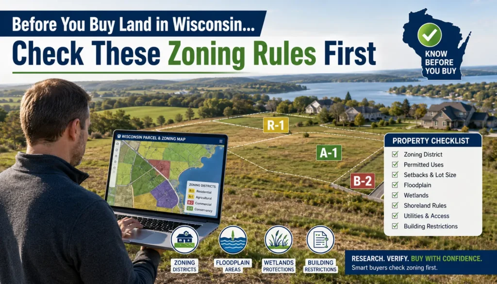
Step 2: Check for Overlay Districts — The Restrictions Most Buyers Miss
Base zoning is only half the picture. Overlay districts layer additional restrictions on top of the base zone without changing the zone designation itself. A parcel can show R-1 on the zoning map and still be 90% unbuildable because of a shoreland or floodplain overlay.
Shoreland Overlay
Wisconsin statutes define shorelands as lands within 1,000 feet of the ordinary high-water mark (OHWM) of a navigable lake, pond, or flowage, and lands within 300 feet or within the floodplain of a navigable river or stream, whichever distance is greater. Shoreland zoning applies in all unincorporated areas.
Lincoln County, for example, applies shoreland zoning regulations to all land within 300 feet of the OHWM of navigable streams and rivers and within 1,000 feet of the OHWM of lakes and flowages. Most Wisconsin counties follow the same state minimum some are more restrictive.
What this means practically: if the parcel is near any lake, pond, river, or stream, there are hard limits on how close you can build to the water, how much of the lot you can cover with impervious surface, and how much shoreline vegetation you can remove.
How to check: Call the county zoning office and ask specifically: “Is this parcel in a shoreland overlay district?” Give them the parcel ID. Also look for a “Shoreland” or “NR 115” layer toggle in the county GIS viewer.
Floodplain Overlay
Flood Insurance Rate Maps (FIRMs) are created by FEMA and the Wisconsin DNR to assign flood risk categories to properties. Zones A and AE indicate high flood risk land within these zones must comply with floodplain zoning regulations.
The Wisconsin DNR Floodplain Management Program’s mapping application allows public access to the Wisconsin Floodplain Analysis database and FEMA’s National Flood Hazard Layer. Note that this layer is for informational purposes only; for regulatory use, view the official Flood Insurance Rate Maps at FEMA’s Map Service Center.
How to check: Go to msc.fema.gov, enter the property address, and pull the FIRM panel. If the parcel falls in Zone A or Zone AE, any new structure must be elevated above the Base Flood Elevation which can add tens of thousands of dollars to construction cost, plus mandatory flood insurance.
Real example: A buyer in La Crosse County found a residential lot priced 30% below comparable parcels. FEMA maps showed it in Zone AE. The seller disclosed it required flood insurance. What wasn’t disclosed: the county floodplain ordinance required any new home to be built with the lowest floor at least 2 feet above the Base Flood Elevation, adding roughly $18,000 in foundation costs before a single wall went up.
Wetland Restrictions
Wetlands in Wisconsin are regulated by both the DNR and the U.S. Army Corps of Engineers under Section 404 of the Clean Water Act. A parcel can look dry in summer and sit on protected wetland soils that make any grading, filling, or construction subject to a lengthy permit process or outright impossible.
How to check: Use the U.S. Fish and Wildlife Service National Wetlands Inventory map at fws.gov/wetlands and the Wisconsin DNR’s Surface Water Data Viewer. Also request a wetland determination from the county zoning office before making an offer on any rural parcel.
Step 3: Understand the Difference Between Permitted Use, Conditional Use, and Variance
This distinction matters enormously.
| Term | What It Means | Your Risk Level |
|---|---|---|
| Permitted Use (by right) | Your intended use is allowed automatically. No board approval needed. | Low — proceed after verifying |
| Conditional Use Permit (CUP) | Your intended use MAY be allowed, but requires board review and conditions. | Medium — not guaranteed, costs time and money |
| Variance | You want to deviate from dimensional standards (setback, lot size). Board must find unique hardship. | High — difficult to obtain, not granted for general convenience |
| Rezoning | Changing the zone classification itself. Requires full public hearing process. | Very high — may take 6-18 months, not guaranteed |
A conditional use permit is required for uses listed as “conditional” within a zoning district. The request is reviewed by the Board of Adjustment. Variances allow development inconsistent with dimensional standards but cannot be issued to approve uses that are inconsistent with the ordinance it is the applicant’s responsibility to prove that variance criteria exist at the site.
Practical rule: If your intended use requires a CUP or variance, do NOT close on the property until you have that approval in hand, or include it as a purchase contingency in the offer. Boards deny CUPs and variances regularly.
Step 4: Contact the County Zoning Office Directly
The county GIS map and the zoning ordinance PDF give you the framework. A 10-minute phone call with the county zoning staff gives you the specific interpretation for that parcel.
Ask these questions word for word:
- What is the current zoning designation for parcel ID [number]?
- Is this parcel within a shoreland overlay district?
- Is any portion of this parcel in the FEMA floodplain or a floodway?
- Are there any known wetland delineations on this parcel?
- Is my intended use (residential / cabin / commercial / agricultural) permitted by right, conditional, or prohibited in this zone?
- What are the minimum setbacks front, rear, side and minimum lot size in this zone?
- Are there any pending rezoning petitions or overlay amendments affecting this area?
Write down the name of the staff member and the date. Get any critical answers in a follow-up email so you have a paper record.
Step 5: Run the Online Tools in This Order
| Tool | What It Checks | URL |
|---|---|---|
| County GIS Parcel Viewer | Base zoning, parcel boundaries | Search “[county] WI parcel viewer” |
| Wisconsin SCO Zoning Data | Statewide county zoning datasets | sco.wisc.edu/data/zoning |
| FEMA Map Service Center | Official floodplain zone, FIRM panel | msc.fema.gov |
| Wisconsin DNR Floodplain Viewer | DNR flood analysis, informational reference | dnr.wisconsin.gov/topic/FloodPlains/mapindex.html |
| USFWS National Wetlands Inventory | Mapped wetland types and boundaries | fws.gov/wetlands/data/mapper.html |
| Wisconsin DNR Surface Water Viewer | Lakes, streams, navigable waterways | dnr.wi.gov (search “surface water viewer”) |
| County Zoning Ordinance PDF | Exact use table, setbacks, permitted uses | Search “[county] WI zoning ordinance” |
Pre-Offer Zoning Checklist
Run every item before you write the offer not after inspection, not at closing.
Base Zoning
- Pulled parcel ID from county tax records
- Confirmed zoning designation on county GIS map
- Located zone in county zoning ordinance use table
- Verified intended use is permitted by right (not conditional, not prohibited)
- Confirmed minimum lot size and setbacks for that zone
Overlay Districts
- Checked for shoreland overlay — distance to nearest navigable water confirmed
- Checked FEMA FIRM — parcel not in Zone A or AE, or cost of compliance calculated
- Checked for wetlands on parcel using NWI mapper and DNR viewer
- Checked for farmland preservation overlay (agricultural parcels)
- Asked county if any other overlays apply (airport approach, riverway, etc.)
CUP / Variance Exposure
- Confirmed no CUP is required for intended use
- If CUP required — included approval as a purchase contingency in offer
- If variance required — assessed feasibility before making offer
Direct Verification
- Called county zoning office, confirmed all of the above verbally
- Received written email confirmation of zoning status
- Asked about any pending amendments, rezoning requests, or overlay changes in the area
Common Zoning Mistakes Wisconsin Buyers Make
Assuming “residential” means buildable. A parcel zoned R-1 in a shoreland area with a 75-foot setback from a lake, a 50-foot wetland buffer, and a side-yard setback can leave a legal buildable envelope of zero square feet. The zone says residential. The overlays say no.
Treating the listing description as a legal statement. A listing that says “perfect for a cabin” or “commercial potential” is marketing, not zoning confirmation. Listings are not legal documents. The county ordinance is.
Not checking the town ordinance separately. Land use laws in Wisconsin can vary dramatically by county, and sometimes by town. Even where county zoning applies, an individual town may adopt additional restrictions on lot coverage, accessory structures, or short-term rentals.
Buying adjacent to agricultural land without checking farmland preservation zoning. Agricultural preservation zoning can restrict what you build on neighboring parcels and can limit future subdivision potential of the land you’re buying.
Skipping the floodplain check on properties that look dry. FEMA Zone A floodplains don’t flood every year. Some haven’t flooded in decades. The map is based on modeled risk and it triggers mandatory flood insurance and construction elevation requirements regardless of the property’s visible flood history.
When You Need a Land Use Attorney
Most residential purchases in established subdivisions don’t require legal counsel beyond a standard real estate attorney. But get a land use attorney involved if:
The parcel’s intended use requires a conditional use permit or rezoning before you can do what you’re planning. The property is on or near a navigable waterway and shoreland compliance is unclear. Any portion of the parcel is mapped as a FEMA floodplain and the seller is claiming the map is wrong (a Letter of Map Amendment may need to be filed). The parcel is large and involves potential subdivision, lot splits, or commercial development. The county zoning office gives you an answer that conflicts with what the listing agent told you.
Land use attorneys in Wisconsin typically charge $200 to $400/hour for a zoning review. A two-hour review on a $350,000 property purchase is cheap insurance.
Quick Reference: Who to Call by Issue Type
| Issue | Who to Contact |
|---|---|
| Base zoning designation | County Zoning or Planning Department |
| Shoreland / NR 115 questions | County Zoning + Wisconsin DNR |
| Floodplain / FIRM questions | County Zoning + FEMA (1-877-336-2627) |
| Wetland delineation | Wisconsin DNR + U.S. Army Corps of Engineers |
| Farmland preservation | County + Wisconsin DATCP |
| Conditional use permits | County Board of Adjustment |
| Town-level ordinances | Town Clerk or Town Board |
| Zoning dispute or appeal | Wisconsin Board of Adjustment + land use attorney |
Editorial Note: This guide is for informational purposes only and should not be considered legal advice. Zoning regulations, overlay districts, and permitted uses may change over time and vary by county, municipality and town. Always verify zoning information directly with the appropriate county zoning office before purchasing property.
Bottom Line
Wisconsin zoning will not stop you from buying a property. It will stop you from using it the way you planned — after you’ve already closed.
Before you buy, confirm the zoning designation, setbacks, minimum lot sizes, allowed structures, conditional use permits, and any shoreland or floodplain overlays. That list is not optional. Every one of those items has produced a costly surprise for Wisconsin buyers who assumed the listing was accurate, the zone was straightforward, or someone else had already checked.
The county zoning office is free to call. The county GIS map is free to use. A 30-minute research session before you make an offer is the single highest-return due diligence step available to any Wisconsin property buyer
FAQ’S
Can I build a house on agricultural-zoned land in Wisconsin?
In many counties, agricultural zoning allows a residence, but requirements vary by county and zoning district.
How do I find a property’s zoning classification in Wisconsin?
You can use the county GIS parcel viewer or contact the county zoning office directly.
Do Wisconsin zoning laws vary by county?
Yes. Zoning regulations are primarily local and can differ significantly between counties and municipalities.
What is a zoning overlay district?
An overlay district adds additional regulations such as floodplain, shoreland, or wetland restrictions without changing the base zoning classification.
Are county GIS zoning maps legally binding?
GIS maps are informational. The official zoning ordinance and county zoning office provide the final determination.